What Causes Local Sea Level Change?
Local and global processes combine to drive sea level change.
Key takeaways
- Relative sea level is the height of the ocean compared to the land next to it. Local sea level is generally given as this relative value.
- Local sea levels depend on changes in land height, ocean currents, and other factors in addition to changes in the global sea level.
- In some places, like the Mid-Atlantic and Gulf Coast regions of the U.S., sea levels are rising faster than global sea level.
- Impacts from temporary changes in sea level during high tides and storms are getting worse for areas where sea level is rising.
Global Versus Local Sea Level
The global sea level is the average ocean height across the entire planet. It gives an overall picture of how sea levels are changing and how the ocean is responding to global warming. Local Sea Level refers to the sea level at a specific location. It is often considered synonymous with relative sea level, which is the height of sea level compared to the land next to it. The local sea level depends on many factors. Changes in land height, ocean currents, and other natural factors all play a role. When factored in, local sea level rise can differ from the global rise by 100% or more.
What is the difference between "sea level rise" and "sea level change"?
Sea Level Change is a broader term that includes both increases and decreases in sea level, affected by various factors. Sea Level Rise is a narrower term, specifically referring to the long-term net increase in sea levels due to global warming and climate change.
Sea level snippets
- Even though there are regional variations, sea level has risen almost everywhere across the globe in the past three decades. From satellite measurements, we know that the sea level has risen in 98% of the ocean from 1993 to the present.
- So much ice is being lost from the ice sheets that it is impacting the rotation, shape and gravity of Earth. Locations that are close to where the ice is melting actually feel less of the resulting sea level rise than locations further away.
Land Height, Ocean Currents, and Other Factors Affecting Local Sea Level
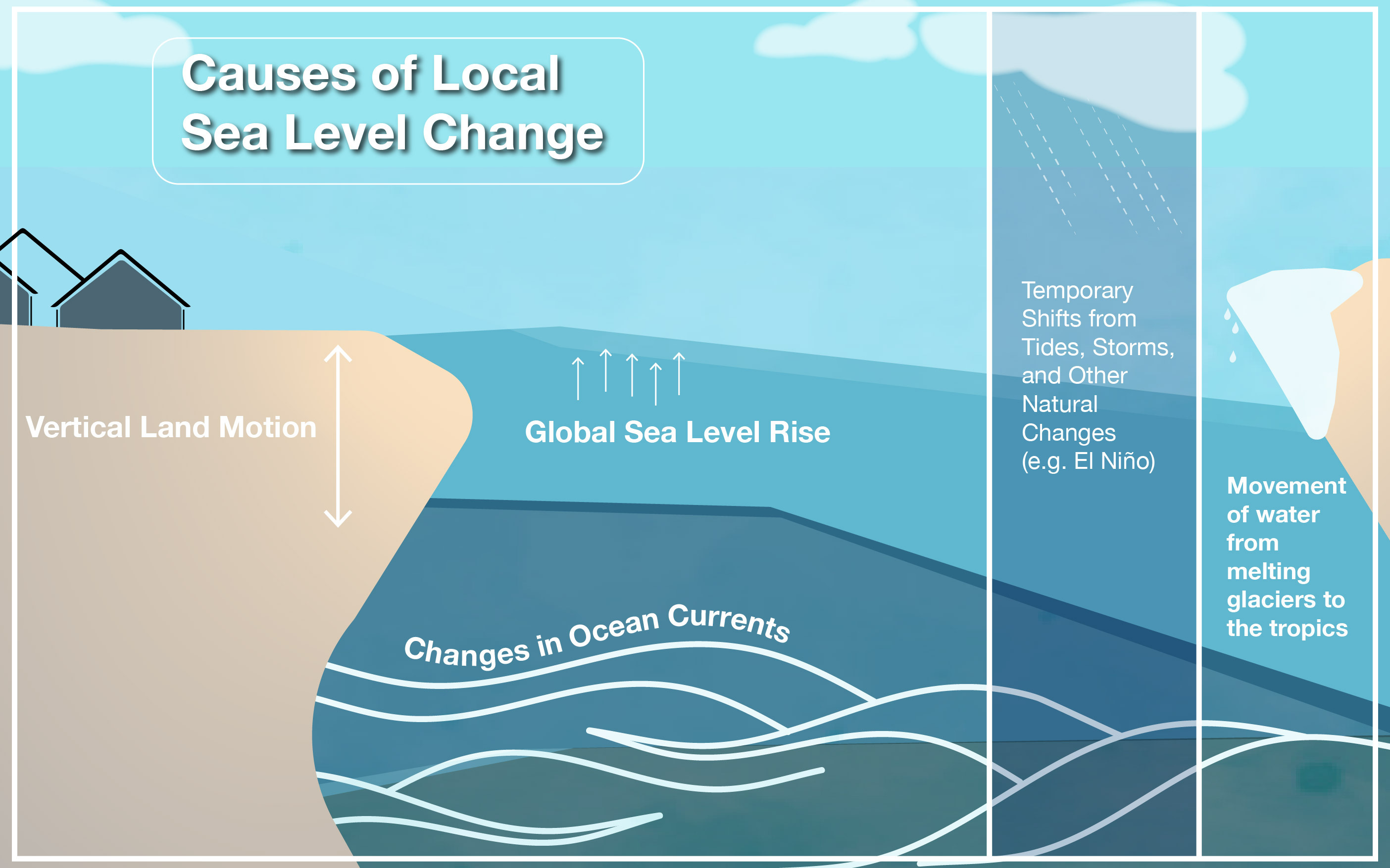
Over years, land can move up or down. This land movement is called vertical land motion. The land moves up and down from natural causes, such as tectonic plates moving or sediment settling, and human causes, like pumping out groundwater or removing fossil fuels from the ground causing land to sink.
When the land next to the ocean sinks, it has the apparent effect of the sea level going up faster in that area. This gradual downward settling or sinking of the Earth’s surface is called subsidence. Conversely, when the land rises, it can cause the sea level relative to land to stay constant or go down. When land rises, as the Earth’s surface moves upward, it is referred to as uplift. Vertical land motion encompasses both subsidence and uplift.
Changes to ocean currents from climate change can also play a role in local sea level rise over time. Ocean currents are like rivers in the sea and help transport heat around the planet. Warmer water and added freshwater from rapidly melting ice sheets to the ocean impact the ocean currents, causing them to shift their speed or location slightly. These shifts can then impact the sea levels in a particular area. These changes are part of what is called sterodynamic sea level change, which is the combined effect on sea level from changes in the ocean’s temperature, saltiness, and motion.

Local and regional changes impact how fast sea levels are rising because they happen in addition to global sea level rise. For example, if the land is sinking next to rapidly warming waters, the local sea level will often rise faster than the global sea level. In the United States, local sea levels are rising faster in the Gulf Coast and Mid-Atlantic regions in particular.
Over hours or days, tides and weather also make local sea levels rise and fall temporarily. These wiggles happen on top of the starting sea level height. For many areas, the increase in sea levels is making impacts from tides and storms worse.
Factors Causing Local Sea Level Change
Vertical Land Motion
A key factor in local sea level rise is vertical land motion. The movement up and down of land is affected by natural and human factors. Natural factors include the movement of tectonic plates, sediment settling, and isostatic rebound which is the ongoing movement of land once burdened by ice-age glaciers. Human factors include groundwater usage and fossil fuel extraction from the ground.
As the tectonic plates move beneath the surface they can move side to side or up and down, especially if one plate is forced under another plate. Depending on the movement and which plate you are on, this can cause the land in an area to rise or sink. Over time, as sediment, or tiny bits of rock, settle and compress, they can make the land sink.
Conversely, the land rises from what is known as isostatic rebound. As the weight of the ice on top of the land literally melts away, the land underneath the ice often rises. This rebound in land height is still impacting some areas from the ice that covered them over 20,000 years ago during the Last Glacial Maximum. Today, this same process is being observed due to climate change as the ice sheets and mountain glaciers melt away. This is causing the land to rise in those areas and can actually lead to lower sea levels than the global value in places nearest to the ice sheets. This is not common globally, but is a factor in specific parts of Alaska.
In other places, ice sheet melting is causing the land to sink. Since Earth is a sphere, the weight of the ice sheets can cause the land below it to compress or sink, whereas other nearby areas bulge out. This is similar to what happens when someone sits on a yoga ball. The area below the weight sinks while other parts of the ball bulge out. As the ice melts and the weight lifts, this causes the land where the ice was to rise, but it also causes the nearby areas that were bulged out to sink back down. This is why sea levels are rising faster in places like the Northeastern U.S. than in other parts of the country.
Human factors are playing an increasing role in vertical land motion along coasts. The pumping of groundwater out of the ground for human use can cause the land to sink. As the water is removed, it creates an air pocket where sediment can fall and settle from above it. A similar process occurs when fossil fuels are extracted from deep within the ground, providing pockets for sediment to fall and fill.
Gravitation, Rotation and Deformation: Ice Sheet Fingerprints
Ice sheet fingerprints are called so because they create unique, location-specific patterns of sea level change around the world, much like a fingerprint uniquely identifies an individual. The fingerprints arise because of changes that happen to the gravitation, rotation and deformation of Earth when ice melts. The deformation or change in the shape of Earth as ice melts is a contributing factor to vertical land motion, as described above. But, these patterns also arise from the complex interactions between gravity, the Earth's rotation, and the redistribution of water following ice melt.

When ice sheets in Greenland, Antarctica, or other ice-covered regions melt, they lose a significant amount of mass. This loss of mass reduces the gravitational pull that the ice sheet exerts on the surrounding ocean water. As a result, water that was previously "pulled" towards the ice sheet starts to redistribute away from the melting region. This causes sea levels to fall near the ice sheet and rise in more distant locations. The gravitational effect is a primary driver of the distinct fingerprint pattern, creating lower sea levels close to the source of melting and higher levels farther away. These fingerprints create a complex pattern of sea level changes that vary significantly across different coastal regions.
The redistribution of water mass due to ice melt also impacts the Earth's rotation. As water moves from higher latitudes (closer to the poles) to lower latitudes (closer to the equator), it can alter the distribution of the Earth's mass. This redistribution affects the Earth's rotational inertia, causing subtle changes in its rotation. These rotational changes further influence sea level patterns globally, contributing to the unique fingerprint effect.
Each melting ice sheet contributes to a global pattern of sea level changes, with its distinct fingerprint superimposed on the effects of other melting sources. For example, the melting of the Greenland ice sheet causes the most variation in the North Atlantic, but has the greatest contribution to sea level rise much further away. Conversely, the melting of the Antarctic ice sheet causes the greatest variability in the southern hemisphere, but impacts northern hemisphere sea level rise most significantly.
Sterodynamic Sea Level Change
Sterodynamic sea level change encompasses the combined effects of steric changes (related to water density) and dynamic changes (related to ocean circulation and currents). These processes contribute significantly to regional variations in sea level.
Steric changes refer to variations in sea level due to changes in the density of seawater, which can be affected by temperature and salinity. When ocean water warms, it expands—a process known as thermal expansion. Conversely, cooling water contracts. This thermal expansion is a significant contributor to global sea level rise, accounting for a large portion of the observed increase over recent decades.
Salinity also influences water density. Freshwater influx from melting ice, rivers, and precipitation can decrease salinity, causing seawater to become less dense. Conversely, increased evaporation can increase salinity, making water denser. These steric changes can lead to regional variations in sea level, as different parts of the ocean experience varying rates of warming and changes in salinity.
Dynamic changes involve the redistribution of water masses due to ocean currents, wind patterns, and atmospheric pressure systems. Ocean currents, driven by wind and the Earth's rotation, play a crucial role in transporting heat and distributing seawater across the globe.
Changes in the strength or position of such currents can lead to significant regional sea level changes. The Gulf Stream, a powerful Atlantic Ocean current, moves warm water from the tropics to the North Atlantic along a steep slope where the ocean is deeper to the east and shallower to the west (closer to the U.S. coast). The current's speed and strength help maintain this slope, which creates a difference in sea level on either side of the Gulf Stream: sea levels are typically lower on the western side (near the U.S. coast) and higher on the eastern side (further out in the Atlantic). When the Gulf Stream slows down or weakens, the slope of the water surface flattens. This change reduces the difference in sea level between the two sides of the current. As a result, sea levels along the U.S. East Coast rise because the water that was held back by the strong flow of the Gulf Stream begins to spread out and accumulate near the coast.
Atmospheric circulation patterns, such as the El Niño-Southern Oscillation (ENSO) and the North Atlantic Oscillation (NAO), also impact sea levels. These patterns can alter wind stress on the ocean surface, affecting the distribution of water masses and causing regional sea level fluctuations.
The U.S. coastlines are particularly affected by sterodynamic sea level changes due to their exposure to various oceanic and atmospheric processes. The East Coast of the United States is influenced by the Gulf Stream and the Atlantic Meridional Overturning Circulation (AMOC), as discussed above. The Gulf Coast is affected by both the Loop Current in the Gulf of Mexico and the broader dynamics of the Atlantic Ocean. Changes in these currents, combined with the region's susceptibility to thermal expansion and freshwater influx from rivers, can lead to significant sea level variations. The West Coast of the United States experiences different sterodynamic influences. Changes in ocean and atmospheric patterns associated with the Pacific Decadal Oscillation (PDO) and ENSO events can lead to variations in sea level. For example, during El Niño events, warmer waters and higher sea levels can impact the West Coast, increasing the risk of coastal flooding and erosion.
Adapted from Sea Level 101 on earth.gov (U.S. Sea Level Change, a coordinated effort of NASA, NOAA and partner agencies). Figures and videos are credited in their captions.